Prolog.
The other evening while I was visiting with Mike and Ivan they told me about a place near Superior where one could find Apache Tears (round nodules of obsidian). The next day Ivan came by and gave me a map showing where the mine was. I decided that it would be a good ride for Friday to see if we could find the mine.The Ride to Superior.
We left the RV around 9:30, stopped at a gas station in Coolidge, filled the tank and headed for Superior. We drove east on 287 to Florence where we got on 79 heading north. At Florence Junction we turned east on 60 to Superior.The map we had said to turn off 60 on Mary Street. Some how we went right past Mary Street with out noticing it. Before we knew it we were going out the east side of Superior (it isn't that big). We found ourselves stuck on 60 for a few miles past the town. We had not been past Superior before and found that the highway went across a very picturesque bridge that crosses Queen Creek.
Not to far past the bridge the highway goes through a tunnel.
There was some road work going on but the ride through the canyon was very pretty with some steep neat rocks on each side of the road.
Once we were out of the canyon we found a place to turn around and headed back to Superior.
Driving Around in Superior.
After driving around the streets of the town and asking directions without much luck, we started back on 60 toward Florence Junction. Just as we were leaving the town on the west side we spotted Mary Street. We turned south on Mary and followed it. We drove around in that area for a while, past the cemetery and the High School. Eventually we found a street called Golf Course that looked like it went south of the town and into the mountains beyond. We were looking for a right turn that went past a Quarry to an old mine. We found a trail going to the right and took it. It came to a working mine with a lot of no trespassing signs on the gate. There was a small road that went to the right, we took it and came to some ones house. There was some people in the yard and we spoke to the man. He told us that the guy that owns the mine didn't want anyone on the property because he has had a lot of vandalism occurring lately and would call the cops on anyone he found there.What to Do.
We left the mine area and decided to follow Golf Course Road south to see if we could find some trails to play on. We found a small track to the right that went to the top of a hill. At the top of the hill we took a look around. We saw some places that looked like an old quarry or mining area so we drove back to the main road and went a little ways south looking for a trail going west.Trail 4.
Our map designated the trail we wanted as FR4. We came to a marker that said Trail 4.We turned onto this trail and entered a bumpy wash.
We drove up hill through the mining/quarry area but didn't find anything that looked like the pictures that Ivan showed me so we continued on.
We took a few side trails that ended in col-d-sacs.
Eventually we came back to the main trail. We turned west and drove a ways in that direction. The trail was pretty rough and at one place we thought that since we were alone maybe we should not go much further.
We took a side trail that was a little less rough and ended up back on Trail 4 past the rough spot.
Once we were back on the trail it smoothed out a bit so we continued along it.
Of course it didn't stay that way but it wasn't so rough that we couldn't do it.
Big Horn Sheep.
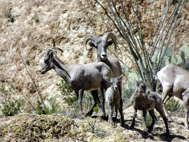
We entered a beautiful canyon.As we got deeper into the canyon Patti spotted some sheep on a ridge not far from the trail.
Unlike Deer who run away as soon as you see them, Sheep tend to pose for pictures. Here is a really nice family portrait.
That in itself is worth the trip.
Looking For a Spot For Lunch.
After taking a bunch of pictures of the sheep we continued along the trail looking for a shady spot to stop for lunch.At noon there aren't many places in the desert to find shade.
We drove along for another half hour or so and eventually saw a small trail going off to the right with a couple of small shady spots so we turned onto this track and had lunch in the shade of a bush.
Awesome Views.
We continued along the trail after lunch enjoying the views.We occasionally past groups of wild flowers.
We passed some interesting rock spires to the south of the trail.
Where Are We?
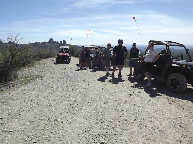
Throughout this whole trip we haven't been sure exactly where we were and where this trail actually went. Yes we did have a map of sorts but we weren't sure where we were on the map. Another concern was, we didn't know if we would have enough gas to make it home. We do carry three extra gallons of gas so we were probably safe enough but when you don't really know where you are on a trail in the desert it can be a concern.Eventually we came to a large turnout with a great view. There was a view sight marked on the map. There were several ATV's stopped at this spot.
When we stopped, I asked one of the people there if this was the view spot marked on the map. He confirmed that it was indeed the marked spot. That was a relief because now I knew where we were and was sure that I could now navigate our way out.
There are a lot of trails in this area and one could spend a lot of time and fuel wandering around if they didn't know where they were at.
We were told that if we turned right at the Ajax Mine and continued taking right turns we would eventually get to Highway 60.
Ajax Mine.
We continued down the trail and came to The Ajax Mine.We didn't spend any time here checking out the mine but I know we will be back.
We took a right turn here and headed north toward Highway 60.
Big Cow Horns.
As we drove along we came across these cows resting in a wash. We were impressed by the size of there horns.I guess if you are a cow living in the desert with Mountain Lions, and Coyote's it is probably pretty handy to carry a formidable weapon to protect yourself and your calves. It is not to unlike living in a modern city now days.
A Deformed Saguaro.
As we continued along we passed another of those deformed Saguaro's that we have been seeing in other places.A Wrong Turn.
After leaving the cows, we came to a crossroads. To me, it looked like the right hand turn would take us back the way we had come so I turned left.Wrong!!
We followed this road for about a mile and came to a locked gate so we had to turn around and head back to where I screwed up. We took the correct road and drove through some more beautiful country.
The End of The Trail.
The road kept getting better as we drove along so I knew we were getting near the end. We stopped at a spot that I remembered from last year and confirmed that we were almost to the highway. Another couple of miles and we came to a large staging area near Highway 60 where we stopped to air up and headed for home.A Surprise Visit and a Nice Sunset.
We got home around 4:30 and I laid down for a short nap. I got up around 5:30 and just as I was coming into the front of the RV, Denis and Sue showed up. We were surprised and happy to see them. We sat outside and visited for a while and made plans to take a ride on Monday.Just as they were leaving Patti and Sue got some nice pictures of the sunset.
It was another good day and an awesome trip.


No comments:
Post a Comment