Monday, February 29, 2016

Wash the Jeep and New Taco Flavors.

Trip to the Car Wash.

For lack of anything better to do today we went to the local carwash and washed the Jeep. It was getting pretty dirty and splashed with mud.

New Taco's.

After the car wash, we went to the taco shop and had a couple of tacos I tried a couple of new flavors. One was called a Cabeza (head); it is beef cheek meat. The other was a Adobada which is pork in a sauce. I liked the Adobada the best. The Cabeza was good but a little dry.

That's about it for now. We are going on a ride today.

Sunday, February 28, 2016

Lunch at the Gila River

Cozy Cove Road.

As we have been driving back and forth along the Florence-Kelvin Highway for the last several days we have been taking some of the side roads to see where they go. One of these roads that we have seen is called Cozy Cove Road. We thought that this road may lead to a nice spot on the river so yesterday we decided that it was time to try it.
We drove out the highway to the Cozy Cove turn off and headed out it. The first thing we came to was this gate.


Not a good sign.
There was a road going to the left here so we followed it down hill for a while.

The country around this area was rolling hills with nice views of the mountains on the north side of the river.


There were several small roads branching off this road. Most of them went to small ranches and locked gates. Others ended in col-d-sac's that may have been building sights. The further we went the more we realized that there wasn't anyway to get through this area to the river.
After trying several trails we ended up turning around and driving back to Florence-Kelvin and going east to Cochran Road.

Cochran Road.

We knew that Cochran Road would take us to the river.
The ride down Cochran Road is very  scenic with great views of the distant mountains.


Following the Wash to the River.

When we came to a large wash that crosses the road we turned north toward the river.


We were driving along the west side of the wash looking for any trails that might go into the rocky hills along that side. We tired a couple but they didn't go anywhere.
We followed one little trail that wound around in the rocks.


The trail was looking encouraging but ended at a small flat over looking a secondary wash with no way down.


Looking for a Lunch Spot

We went back to the main wash and continued heading toward the river. We came to a place where we had a weenie roast last year.


There were a couple guys target shooting there so we turned to the east and climbed over the hill on a rocky road.


From this trail we could see the railroad trestle that goes over the river.


We dropped down the other side into the main wash and drove through a gate near an old ruin.


This trail goes near the tracks and the trestle so we stopped and I walked on the tracks to get a picture of the trestle where the tracks go into a tunnel on the other side.


We continued along the trail and stopped at a shady spot at the rivers edge.


We thought that we might have lunch here but the trees were starting to bloom and they were full of bees so we decided to go to another spot.

We went up stream to the place where there is the crossing for the trail that comes from the Coke Ovens.
We set out the chairs and had lunch here.


 While we were having lunch we discussed that it would be good if some jeeps would come to the river from the other side and try to cross. We were told a few days ago that the river couldn't be crossed here this year but it looked okay to us.

Jeeps Cross the River.

Just as we were finishing our lunch we could hear some jeeps approaching the river from the other side.


There were two of them one TJ and a four door Wrangler. They checked out the river access and after one of the guys waded across the river, they decided that it was passable.


The first one to attempt the crossing was the TJ.


He made it with no problem.


Next was the four door's turn. He wasn't as tall at the TJ so it looked a bit mor interesting.


He also made it just fine.


Well, I  guess that proves that the river is indeed crossable at this place.

After the other jeeps had left we packed up our stuff and started back toward the main wash and home. At the gate we caught up with the other jeeps. The lady in the TJ was holding the gate open for us as we came up. That was very nice of her. We passed them and drove back on Cochran Road and stopped at the staging area near the highway where we aired up and talked to the other jeepers a bit, then headed for home.

It was another good day playing in the desert. 


Saturday, February 27, 2016

Day of Rest.


As you have probably figured out by now, We took yesterday off.

I worked on the blog until around 1:00.
We were thinking of going to see a movie but couldn't find anything we wanted to spend money to see so we just stayed home.
We did go to Walmart where I bought a new Garmin GPS. Some how I lost the old one. It will probably show up now that I got a new one. I was ready to upgrade anyway so I hope I got the right one. It appears to be better than the last one so we will see.

We are taking a ride today so I will have something to share with you tomorrow.

Friday, February 26, 2016

Four Peaks and Apache Trails in One Day

Prolog.

We have been looking at doing a very long trip that starts with the Four Peaks Trail east of Mesa.


and returns via the Apache Trail to Apache Junction.


Getting to the Four Peaks Trail.

We left around 8:15 and at the north end of Coolidge we drove west on 87 to Gilbert Road (about 20 miles). Here we drove north through the town of Gilbert (about 25 miles).Where we picked up Highway 87 again N/E of Mesa. As we were driving along, six trucks carrying ATV's came on the highway at an on ramp.


 We ended up in the middle of them. I figured that they were probably going to the same place we were. We continued east on 87 and just before mile post 204 all the trucks turned off at the Four Peaks trail. We followed them to a large staging area where we stopped to air down.

On The Trail.

After airing down we headed out the trail. It started out as a wide gravel road.


After a while the gravel changed to graded dirt.


Along the road are some interesting rock formations.


At a high point we looked back toward the Mesa/Phoenix Megalopolis.


Eventually the trail becomes smaller and winds through granite mountains.


We crossed a couple of very small streams.


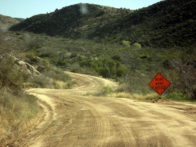
We noticed that there were signs of grader work on the road. Eventually we passed this sign.


I'm not sure if the grader guy was trying to make the road smoother or more challenging.


Eventually we caught up with the grader and passed it.


We could still see signs of his work but the road was a little smoother.


Others on the trail.

Eventually we caught up with a group of Jeeps and ATV's.


We followed them for a while but the dust became too much so we stopped for a while and let them get way ahead.

Interesting Rocks.

As we went along we saw some interesting rocks.

This one reminded us of wax lips.


 This one kind of looks like a pioneer woman in her long dress and bonnet.


Snow on the Mountains.

As we climbed further up the mountain we could see snow on the peaks to the south of us.


A Split in the Trail.

We came to a place where the trail splits.


The left fork goes to an overlook. The right fork drops down the east side of the mountains to Roosevelt Lake and Highway 188.

We took the left fork and the trail climbed to over 6000 feet. We even found a little snow on the trail.


Interesting Mixed Forest.

The trail goes through a mixed forest with several kinds of trees.
There are Long Needle Pines.


Short Needle Pines.


Junipers.


Alligator Cedars.


Oaks.


Manzanita.


And Others.

Lunch at an Overlook.

We followed the trail for about six miles until we came to an overlook, we stopped here for lunch.


From here there is a good view of Roosevelt Lake.


Coming Down off the Mountain.

After lunch we drove back to the main trail and started down the mountain toward Highway 188.

Here is a view of the Four Peaks from the trail.


 Here is a view into the valley.


We drove around this interesting round about.


Change of Plan.

Once we got to the Highway I was really tired and decided not to take the Apache Trail so I aired the tires up.
We drove south on 188 along the west shore of Roosevelt Lake and came to the bridge crossing the output of the lake.


Apache Trail.

Just across the bridge, Highway 88 (The Apache Trail) turns off to the east toward Tortilla Flat and Apache Junction.
We stopped at an overlook below the dam and took some pictures.


Okay, so I changed my mind again and decided to take the Apache Trail after all.
I only wish that I had not aired the tires up. The road starts out paved for about a mile. Then becomes a graded dirt road. I don't know when it was graded last but this time it has some of the worst washboard that I have seen in a while.


Apache Lake.

The road follows Apache Lake. The lake is very long and goes through some beautiful scenery.


The road enters a steep canyon.


As we crossed this bridge we could see a big cave on the other side. If you look closely you can see the effects of years of fires in the cave, showing that they were occupied for centuries.


The trail narrows and climbs the canyon.


At the top the canyon opens up and you drop into a valley and the old mining town of Tortilla Flat.


By this time we were getting pretty barn sour and didn't want to stop.

After going through Tortilla Flat the road goes along the shore of Saguaro Lake.


Eventually we got to Apache Junction. After a bit of confusion we finally got onto Highway 60 and headed for Florence Junction. At Florence Junction we got onto Highway 79 to Florence. Here we got on Hwy 78 and drove to Coolidge.
We stopped for dinner at Tag's Restaurant and were home by 7:30.

The whole trip took us eleven and a half hours.
It was a long ride and I don't think I would want to do it  again.