Saturday, February 27, 2010
On February 16th. we took a ride to Dripping Springs (see blog for that date). We hadn't expected to go there but it just turned out that way.
Yesterday we went back to that area because I wanted to check out some more roads.
We drove past the wash that eventually leads to Dripping Spring and continued south until we came to a trail going east into the the mountains. We followed this trail to its end in an area that has a bunch of quartz outcrops. Some of them looked like quartz waterfalls cascading down the mountainsides. Some others were close to the trail. We stopped near these and every one combed the area looking for crystals.
Becky and Missy found a few small clear ones. We spent about an hour there then drove back to the north south trail and continued on a southerly course until the trail turned east into a wash. Becky got a nice picture of a hawk in a tree along the way.
The going got tougher and tougher until we got to a point where we could go no further because of the large boulders in the bed.
We stopped here for lunch
and then retraced our route down the wash. We came to a branch in the wash that went south so we turned on to it. The going wasn't to bad but there was one spot that was pretty tight and we weren't sure that Juniors wider jeep would make it through unscathed.
He took it slow and made it with no problem.
A little later we came to another of the Game water areas.
From there the wash got wider and easier to travel. It looked like we would be out of it in a little while. When we came to an intersection I turned east again and after a while Patti and I realized that we had been here before (See blog for Feb. 13)
We stopped at a wide spot do discuss which way to proceed. After discussing the options we decided to drive over the mountains on a steep trail
that eventually goes past the Mailbox cabin.
We passed the M.B.C. and drove over the I-10 overpass to a dirt pipe line trail that goes along the north side of I-10 to quartzsite.
Here is the map.
Wednesday, February 24, 2010
When we left Laughlin NV on Saturday, storm clouds were darkening the sky and the smell of rain was in the air. As we traveled south the winds grew stronger and rain squalls swept across the desert. By the time we got to Quartzsite we had left the rain in the north but the wind still blew hard enough that we had to put the awning away and batten down any loose gear.
Sunday was cold and windy and by Monday morning the rains swept down from up north and it poured for half the day.
Cabin fever was setting in by Monday afternoon so we made plans with Becky, Dennis , Missy and Junior to take a ride the next day to the Castle Dome ghost town/museum vie McPherson Pass.
We left by 9:00 am. By 9:45 we had unloaded B&D's Rhino at Stone Cabin and were on our way.
We took a side trip to the horse tanks so that the others could see the tanks and the Indian cave there.
Then we headed south on the McPherson pass road.
It took us about three hours to get to the museum. I was surprised by all the traffic. Patti counted 25 other vehicles on the trail, and that was only the vehicles we passed or passed us in both directions.
We asked at the museum and were told that they had had over 125 visitors that day.
The Castle Dome Ghost Town Museum is an interesting place. It is the work of one man with a dream and an enormous amount of energy. Many of the buildings were purchased from mines in the area, dismantled and rebuilt on the museum sight. Some of them were built from scratch.
Patti and I have been to the Museum three times.
OK, here are the pictures.
I've been framed!
The Quartzsite gang.
Ladies of the Castle Dome hotel.
Would you accept a drink from these guys?
Crime doesn't pay.
Look out for this one.
Waiting at the highway for Dennis to get his truck to pick up the rhino.
We got home around dark.
If you are interested to learn more about the museum here is a websight you can check out.
http://www.azcentral.com/travel/arizona/features/articles/0601castle0601.html?&wired
Friday, February 19, 2010
After breakfast at the Black Bear Cafe, we headed down AZ 95 to Mojave Valley where we turned east on Willow Dr. After about 5 miles, the back road to Oatman began.
The road is not real challenging but is very bumpy due to the many fist size to basket ball sized rocks in its bed. We bounced along for about 2 hours keeping a mountain called Boundary Dome in our sights.
We followed the directions in;
"A Guide to Arizona Backroads & 4-Wheel Drive Trails" by Charles A Wells.
His description was very close to what we found on the trail. And historical information about things to see were informative. Such as, the concrete reservoir near the old town sight of Milltown.
The water was used for the steam engines that ran the 40-stamp mill that crushed ore from the mines near Oatman and the old railroad bed for the Mojave and Milltown Railroad that brought the ore from the mountains.
Boundary Dome loomed larger as we neared Route 66
We turned north on 66 and drove into Oatman.
The mines have played out but now they are mining the tourists.
It must be a character flaw but I have always had trouble with Tourist Traps. They are all the same with their "T" shirt stores and gift shops.
Oatman isn't much different than other old west towns; it has the obligatory fake gun fights and western style saloons. The one difference in Oatman is the tame/wild Burros.
They wander up and down the main street begging for carrots and some times being very insistent, nipping at loose clothing when the tourists run out of the sweet veggies.
Its hard not to be enchanted by the creatures though.
This one didn't want us to leave and stood behind the Jeep for a long time . I finally had to have Patti get out ans shoo him away. I didn't think I would make any friends if I backed into him.
Well that was our trip to Oatman.
When we got back to The Colorado Bell, Patti headed for the casino while I went to the room to go through the pictures of the day.
She returned around 4:45 and we went to The Outback for dinner.
Even with what Patti spent for last nights dinner she came out even for the two days of gambling. She is a winner as far as I am concerned.
We will head for home (Quartzsite) in the morning.
Thursday, February 18, 2010
Tomorrow is Patti and my 4th wedding anniversary.
We decided to return to the scene of the crime, so this morning we drove to Laughlin Nevada (Las Vegas for Seniors). Not so much to relive the wedding but hopefully to relive the honeymoon.
We got to the hotel (Colorado Bell) around 1:30. We registered and took our stuff to the room.
For two nights it cost us just under 100 bucks. Not to bad. The room was on the third floor and had a view.
Well, OK, I didn't say that it was a good view.
After a short rest Patti headed for the casino and I drove Clifford to the Big "O" Tire Shop, to get the tires rotated.
Pretty exciting stuff eh?
When I got back to the room, Patti was still gambling so I took a short nap.
Patti got back to the room around 4:45, she had won about 30 dollars on the machines, so she said that dinner was on her. We went across the road to the Tropicana Express for the $7.95 all you can eat Prim Rib buffet. To get the 7.95 deal you had to get a players club card so we got in line for the club card. While we were getting the card the lady there asked us what our anniversary date was and when we told her that it was tomorrow she gave us two "T" shirts. Kind of funky but they were free!
The Prime rib was good so naturally I ate a little to much.
After dinner Patti went back to the casino and I came up here to the room to write in the blog and digest the prime rib.
Tomorrow we plan to got to the ghost town/tourist trap of Oatman AZ. If we can find the turn off we are going to go via the back road. What the heck, I have to figure out a way to do some jeeping eh.
Until tomorrow then.
Wednesday, February 17, 2010
This morning Patti and I were outside when Junior came by. We got to talking and he told us about he and a friend exploring the Apache Chief mine the day before.
While we were discussing it, Becky and Dennis came over and after a bit we all decided that it sounded like a fun thing to go see, so after lunch we took off for another adventure.
We headed east on I 10 and turned off at Gold Nugget Rd. Becky and Dennis road in Junior's jeep with Junior and Missy while we followed in Clifford.
It was kind of nice to not be the leader for once.
It was only a short trip out to the Apache Chief which is close to the mailbox cabin. When we came to the entrance to the tunnel,
Dennis and I realized that we had been here before and had gone in a short way.
At that time we didn't have any lights.
This time we were prepared. We all had a light of some kind. I had three.
Junior, our guide went in first.
Once through the small entrance the tunnel opened up so we could walk upright.
The mine was extensive with several side tunnels and large rooms.
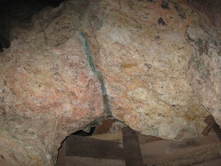
In the sealing we could see some veins of copper.
Dennis and I stopped to check out some side tunnels and had to hurry to catch up.
At one point we could see light ahead and came to a large vertical air shaft.
Not all the verticals were open to the sky. I suspect that there are many layers to this labyrinth.
Near the end of the tunnel the floor sloped down at a steep angle.
We had to slide down on our butts.
Once we slid down the slope it was only a short distance to the exit.
The tunnel went clear through the mountain.
When we were out in the open we walked over the hill and back to the Jeeps.
The description below was copied from mindat.org;
A Cu-Ag-Au-Fe-Pb-Zn mine group located in the NE¼ sec. 12, T3N, R18W. Owned at times, or in part, by early Spanish and/or French operators; Eichelberger & Rivera; Success Copper Mining Co.; Arizona Success Mining Co.; Hickman; Richman; Apache Mines Syndicate; Old Apache Mines Co.; Arizona Apache Mines Co.; Aplington & Ehlers; Williams; Aplington; Apache Metals, Inc.; Brown; Klix; Swires; and, the Apache Chief Mining Co.
Mineralization is spotty copper and silver minerals with minor gold, lead, and zinc, largely oxidized, in irregular, small, lensing fingers, pods and ore shoots along a shear zone with quartz in a thrust-faulted jumble of contact metamorphosed Paleozoic limestone, Mesozoic continental red beds, and Laramide conglomerates, intruded by diorite dikes and small quartz porphyry intrusives. Enrichment of copper and silver by oxidztion. Strong iron gossan.
"Workings include a shaft 225 feet deep (1881) and a 100 foot long tunnel (1881) with extensive underground workings. Total estimated and recorded production for the group, from intermittent operations from at least the early 1860's through 1967, would be some 2,100 tons of ore averaging about 11% Cu, 12 oz. Ag/T, and 0.03 oz. Au/T. About 700 pounds of lead were also produced."
Today was one of those unplanned adventure.
Some times those are the best kind.
I think, the ladies were having fun.
Some of the above photoes were taken by, Becky and Suzanne aka.(Missy).
Tuesday, February 16, 2010
Wow, the weather has finally gotten warm enough for Clifford to go topless and doorless.
I have a lot of pictures this time so I'll try to keep the words to a minimum.
OK, yesterday we took a ride with Becky , Dennis, Missy (Suzanne) and Junior (Denis).
We headed south from Quartzsite to the long term visitors area on the south end of town. It is a large section of desert that the BLM runs as a fee camping area.
The road we wanted runs east through the camp ground and then southeast toward the mountains. We followed the road for a a few miles then we tried a few trails going into the mountains. Most turned out to be dead ends. We stopped to check out a quartz outcrop
and drove up and down some steep hills.
Eventually we hit on a track that entered a wash and went all the way through the mountains. Along the way we saw some Big Horn Sheep.
These are the first ones we have seen in the last two years, also we saw some early wildflowers.
As we traveled along, the trail began to get a little rocky.
Check out this short video.
The going got tougher
Eventually we had to spot for each other to get over the rocks.
We even had to add a few rocks.
This was the worst spot but we all made it through with a little work.
Dennis and I decided to go around this one
And did a good job of it. After passing the last of the rocky area we all felt like manly men.
The wash entered a very narrow section.
Along this stretch we came to another memorial.
This one was for Mr. Bill 1920 to 2006.
We finally got through the wash and climbed over some steep mountains. After a while Patti suggested that I run a track on the Net book to see if we may have passed Dripping Spring so we pulled over at a wide spot where I connected the GPS to the net book and sure enough we had passed the turn off back in the narrows. We turned around and headed back over the hills and into the wash again where we found the turn off to Dripping Spring. It is in a small cave against a steep rock wall.
No! Dennis is not peeing in the spring. It was nice and cool in the shade near the spring.
Along the trail to the spring are many Petroglyphs.
We left the spring and headed east where we eventually came to the mailbox cabin.
From there we headed for home via the rout that Patti and I tried to find on our ride last Saturday. There is one spot on this trail that is very narrow and Junior had a scary time getting passed it. I didn't realize that his jeep is five inches wider than mine. The trail is so narrow that the five inches made the jeep almost too wide to get between a rock bank on the left and the cliff on the right. Fortunately he got through OK. We stopped at an old abandoned rock cabin
From there it was about a half hour drive home. Here is the map.
What a great ride! It was challenging, exciting and beautiful.